


 Regional disputes can arise at any time. Either they blow out of proportions or, at times, countries use diplomatic initiatives to reduce enmity. What began in May 2020 was a row between India and Nepal when New Delhi inaugurated the Himalayan road link. It was a part of India’s plan to expand its road routes in the region for trade and commerce. However, the Indian road link passed through Kalapani. This disputed region has been under siege since 1998. While India claims the area comes under its control, Nepal also claims its ownership.
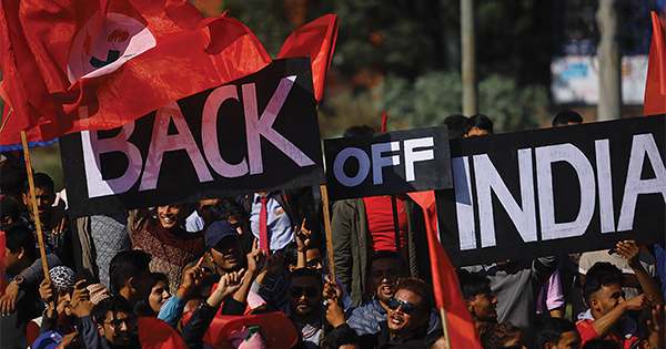
At a time when the world is facing the atrocities caused by the Covid-19 and lockdowns, India and Nepal are preparing to lock horns. The border dispute between the two neighbours may as well expand.
India’s inauguration of the 80-kilometer (50-mile) Himalayan link road passes through Lipulekh Pass. It is on the border between India and China, near their junction. The Kalapani territory is situated on the southeastern side of Lipulekh Pass.
According to the plan, this Himalayan link road, a unilaterally built motorway by India, connects the Indian state of Uttarakhand to Kailash Mansarovar situated in Tibet. Historically speaking, the Lipulekh Pass is also the shortest trade route between India and China. It is yet to be seen how China will view the inauguration of this link road, given that Chinese and Indian armed forces have been engaged in a conflict in the Ladakh region. Nepal, however, considers that the Himalayan road link is a way to bully smaller countries of the region. The controversy of the Himalayan link road is that a 17-kilometer part of the road passes through Nepalese territory.
Stepping up the game of conflicts, the Prime Minister of Nepal, Khadga Prasad Sharma Oli issued a map of Nepal. According to it, Nepal owns the areas of Kalapani, Lipulekh, and Limpiyadhura. The Nepalese government also claims that these areas were never under colonial rule. According to reports, the areas were brought under Nepal’s administration in line with the Sugauli Treaty with the British Raj following the Anglo-Nepalese (Gurkha) War in 1816. The Nepalese government has planned to use this new map for administrative purposes. It will also be put in textbooks. This may well compel India to do the same. If this is the case, students on either side of the border will not get the true picture of geography and geopolitics of the area.

The writer has a special interest in the region’s social and political affairs. He can be reached at omariftikhar82 |
|
Cover Story
|
|
Tributes
|
|
Special Editorial Feature
|
|
News Buzz
|
Update |
Leave a Reply